
A long-promised walking, wheeling and cycling route between Aviemore and Carrbridge is moving closer to a formal planning decision after years of design work, consultation and uncertainty over whether the scheme would be delivered alongside the A9 dualling programme. VIEW MAP
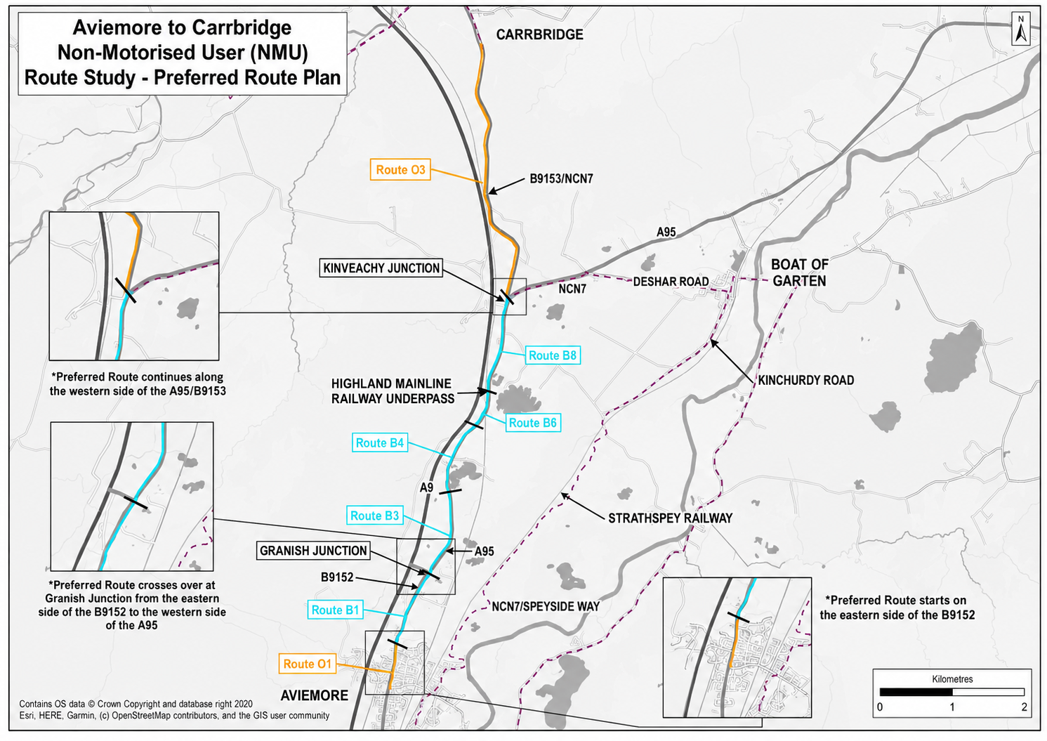
The proposal is for a fully segregated non-motorised route running for about 10 kilometres between the two communities, following the B9152, A95 and B9153 corridors. Most of the route would be newly constructed, with some existing paths resurfaced and widened to meet a three-metre standard.
The scheme has been promoted by Transport Scotland and was developed as a separate project from the A9 Dalraddy to Slochd dualling works. Transport Scotland has previously said that, if the route secured its statutory consents and necessary land in time, provision could be made for it to be incorporated into the wider A9 construction contract.
That qualification has become one of the central issues around the project.
The route has been discussed for years. A formal Proposal of Application Notice was considered by the Cairngorms National Park Authority in August 2022, when planning members were told the scheme would create a new shared-use route between Aviemore and Carrbridge and that an Environmental Impact Assessment would be required.
The proposal is classed as a major development because its length exceeds eight kilometres.
Its intended alignment begins near Dalfaber Drive in Aviemore, continues north alongside the B9152, crosses the Granish junction and then follows the A95 and B9153 towards Carrbridge. The design seeks to keep closely to existing road corridors in order to limit woodland loss, disturbance to protected species and wider landscape impacts.
The route is not simply a leisure path.
Highland Council has described it as a future off-road connection for walking, wheeling and cycling between the two settlements, providing a safer alternative to existing road travel and linking with other routes in and around Aviemore. Cycling data published by the council has also shown substantial everyday use of bikes in Aviemore, including clear peaks around normal commuting times.
The project has nevertheless had an awkward relationship with the wider timetable for A9 dualling.
Cairngorms National Park Authority documents published this year show that the proposed route has not been included in the latest draft Core Paths Plan because its final alignment has not yet been confirmed and not all the land required is currently within access rights.
The authority also questioned whether the route would actually be delivered within the lifespan of the current Core Paths Plan. It concluded that designation as a core path would add little to the delivery process because the scheme is already identified among the commitments associated with A9 dualling. The route could instead be added after construction is complete.
The route remains an identified transport commitment, but its existence on planning and policy maps is not the same thing as a completed path between the two communities.
Planning members recognised that problem as far back as 2022, when the Cairngorms National Park Authority agreed that officers should explore whether partners could take the Aviemore-Carrbridge route forward independently of the A9 dualling programme.
Four years later, the project remains closely tied to decisions surrounding the trunk-road works.
Sections of the proposed route lie beside or pass through parcels of woodland included on the Ancient Woodland Inventory. Although the alignment does not itself fall within statutory nature conservation sites, several protected areas lie in the wider vicinity. The planning process therefore has to consider habitat effects alongside the transport case for a safer off-road connection.
The project also has to negotiate junctions and transitions between dedicated path and public road.
Earlier design material shows that cyclists travelling north into Carrbridge would eventually transition back onto the B9153 carriageway. That means the claim of a wholly segregated route applies to the planned connection itself, while the onward journey within or beyond Carrbridge still depends partly on the existing road network.
The wider active-travel programme in Aviemore has meanwhile encountered its own limitations.
A Cairngorms 2030 delivery report published in March found that there was not enough room on part of Grampian Road for a bidirectional segregated cycle path without substantial land acquisition, removal of mature trees and realignment of the carriageway.
That section was consequently removed from the current Aviemore concept design. The revised work focuses instead on improved pavements, wheelchair access, public realm, bus-stop integration, traffic calming and an alternative cycle-friendly route on Dalfaber Road.
The same report says a short shared-use path north of Dalfaber Drive would help bridge the gap between the built-up area and the starting point of the Aviemore-Carrbridge route.
That makes the proposed inter-urban path more important to the overall network, but also exposes the dependence of one project on another.
The original case for the scheme is straightforward enough. Aviemore and Carrbridge are close enough for cycling to be a realistic everyday journey, but the existing road corridor is not an attractive option for many people on foot or bike. A continuous, segregated route would create a connection that currently does not exist in a consistent form.
The project has already passed through route appraisal, consultation, environmental assessment work and several years of planning preparation. Its connection to the A9 programme was intended to provide an efficient route to construction, but the prolonged timetable surrounding the road scheme has also left the active-travel project exposed to the same uncertainty.
The immediate planning process now offers a chance to separate two questions that have often been treated together: whether the route should be allowed to proceed, and when somebody will actually build it.
For residents of Aviemore and Carrbridge, the second question is likely to be the more important one.
Sources
Cairngorms National Park Authority — Proposal Of Application Notification: Non-Motorised User Route Between Aviemore And Carrbridge
https://cairngorms.co.uk/documents/item6aapre20220016informationpaper/
Cairngorms National Park Authority — Appendix 1: Aviemore To Carrbridge Non-Motorised User Route
https://cairngorms.co.uk/documents/item6appendix1panpre20220016/
Cairngorms National Park Authority — Core Paths Plan Issues Report 2026
https://cairngorms.co.uk/documents/core-paths-plan-issues-report-2026/
Cairngorms National Park Authority — Planning Committee Minutes, 26 August 2022
https://cairngorms.co.uk/documents/220826pcminutesv10/
Cairngorms National Park Authority — Cairngorms 2030 Delivery Update, 23 March 2026
https://cairngorms.co.uk/uploads/documents/Performance-Paper-2-Cairngorms-2030-Delivery-Update.pdf
Transport Scotland — Aviemore To Carrbridge Non-Motorised User Route Study: Route Options Appraisal
https://www.transport.gov.scot/media/50481/route-options-appraisal-report-aviemore-to-carrbridge-non-motorised-user-route-study.pdf
Highland Council — Aviemore Among Dozens Of Scottish Locations To See More People On Bikes
https://www.highland.gov.uk/news/article/16738/aviemore_among_dozens_of_scottish_locations_to_see_more_people_on_bikes