

Scotland now hosts a layered network of military, nuclear, aviation, space, and environmental pressures. Some of it is historical and deeply woven into the landscapes of Argyll and Bute or Angus. Some of it is modern and far harder to see, moving silently through Highland territory, the Western Isles range, and Scotland’s northern waters. The public record reveals a nation heavily utilised for North Atlantic defence: submarine surveillance, nuclear deterrence, complex logistics, missile training, and an emerging orbital space launch sector spanning from the Hebrides to the Shetland Islands. While Scotland witnesses this massive infrastructure footprint, it controls very few of the strategic decisions driving it.
(NOTE: This is an editorial map. Some areas may appear distorted and locations are not exact).
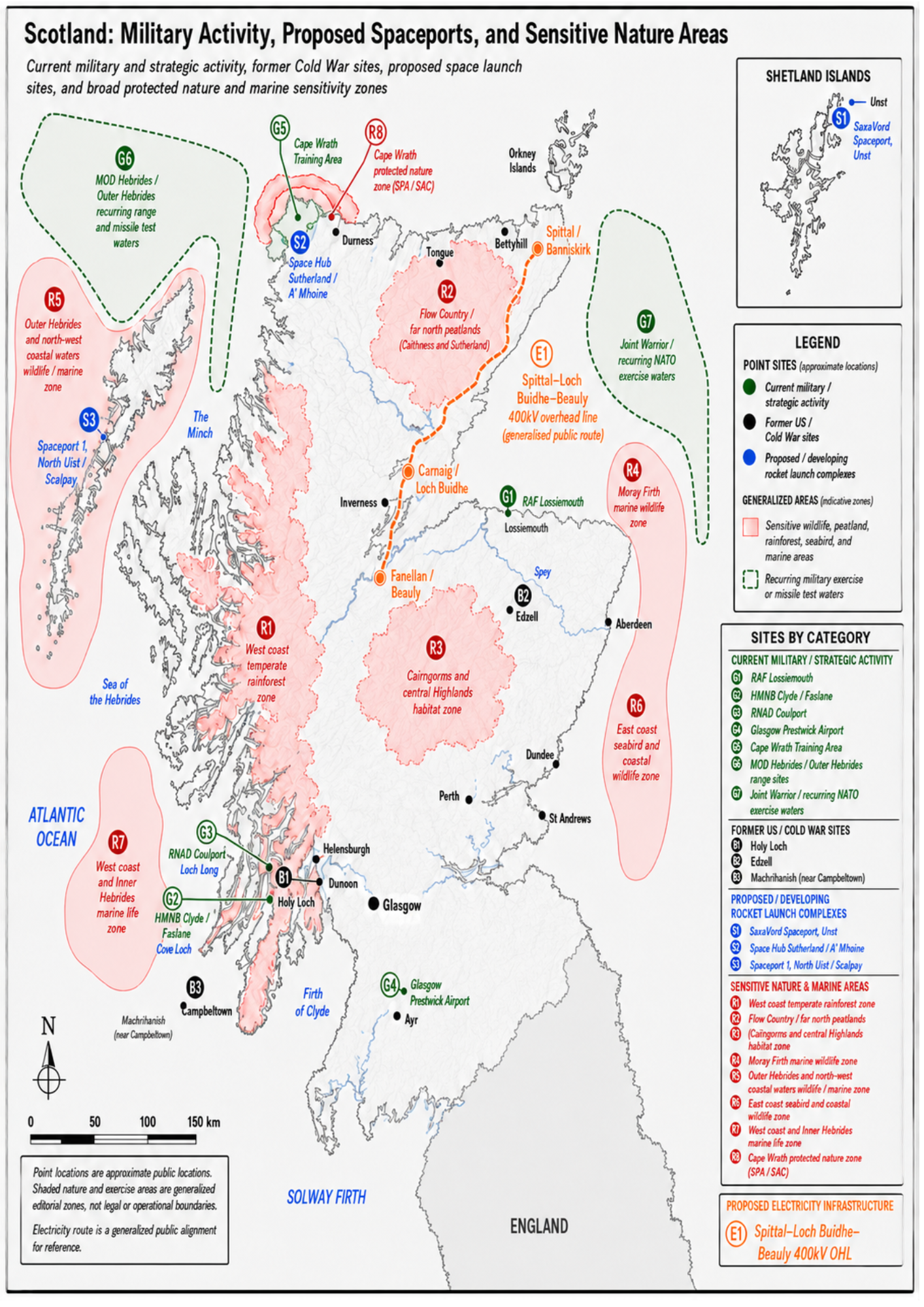
This map is uncomfortable because it forces several conflicting truths onto a single page. It is explicitly an editorial map, not a legal document or a scientific impact assessment. It is meant to show visual overlaps and spark the hard questions Scotland should be asking, rather than to prove localised harm at every single coordinate.
Scotland is a country of rainforest fragments, seabird cliffs, peatlands, marine mammals, machair, island waters, and protected seas. Yet it is simultaneously a country of nuclear weapons, expansive military ranges, US Navy logistical support, NATO exercises, and high-tech rocket launch sites.
These realities are usually discussed in isolation. They should not be.
The Dispersed Footprint of Modern Defence
American military activity in Scotland no longer mirrors the highly visible Cold War bases once found at Holy Loch, Edzell, and Machrihanish. Those prominent installations are long gone. Holy Loch closed in 1992. The US Navy vacated Machrihanish in 1995, and RAF Edzell in Angus closed its gates in 1997.
Today’s strategic footprint is more dispersed and integrated into modern infrastructure. It manifests through shared airspace, maritime patrol agreements, refuelling stopovers, and space infrastructure contracts. It is harder to spot than an American flag flying over a guarded base gate, but its strategic weight remains immense.
The driving factor is pure geography. Scotland sits on the northern approaches to the Atlantic. From this vantage point, allied aircraft and ships monitor the North Sea, the Norwegian Sea, the Greenland-Iceland-UK gap, changing Arctic trade routes, Russian submarine movements, and the vital undersea cables linking North America with Europe. This critical corridor is exactly why Scotland remains indispensable to the United States, the UK, and NATO.
Submarine Hunting in Moray
RAF Lossiemouth in Moray stands as the clearest current example of this integrated infrastructure. It serves as the home base for the RAF’s nine P-8A Poseidon maritime patrol aircraft, which are heavily utilised for anti-submarine warfare and maritime surveillance. The P-8A is an American-designed Boeing aircraft operated closely alongside the United States Navy.
In 2024, a dedicated US Naval Support Facility opened at Lossiemouth to accommodate returning American forces. This followed a massive six-year, £350 million upgrade completed by the Ministry of Defence. The project delivered advanced accommodation, drainage, and electrical grids, alongside a specialised, large enclosed wash facility built specifically to maintain US Navy P-8A Poseidon aircraft.
The operational objective is direct: tracking underwater movements. US Navy P-8A aircraft regularly operate from Lossiemouth during joint NATO exercises, embedding the Moray coast deeply into a global allied system built to find and track submarines.
The Nuclear Infrastructure on the Clyde
The second major strategic layer sits directly on the Clyde in Argyll and Bute. HMNB Clyde, comprising Faslane and Coulport, hosts the UK’s nuclear-armed Vanguard-class submarines and nuclear-powered attack fleets. Coulport is responsible for storing, handling, and loading Trident II D5 missiles and the UK’s nuclear warheads.
The American connection is entirely hardwired into this infrastructure. The UK Government openly acknowledges that the Trident missile system is designed and manufactured in the United States. Under long-standing bilateral agreements originating with the Polaris Sales Agreement, the UK buys title to these missiles from a shared, US-managed pool.
While the command structure on the Clyde is entirely British, the core weapon system relies completely on American origin, procurement, and ongoing technical support. Scotland provides the physical bedrock for the UK nuclear deterrent, but the machinery of that deterrent is anchored across the Atlantic.
Blue Zones: Commercial Space or Dual-Use?
The blue regions highlighted on the map, the developing rocket launch complexes, are not confirmed or active US military bases. They are civil and commercial projects, but by their very nature, modern space launch infrastructure is inherently dual-use. The exact same infrastructure used to deploy commercial, scientific, or communication satellites can support defence, surveillance, navigation, or intelligence-linked payloads if licensed and approved by the UK Government.
These blue areas are heavily backed by global corporate interests.
SaxaVord Spaceport (S1) in Shetland became Europe’s first fully licensed vertical orbital spaceport in December 2023. Its operational trajectory tracks prominent partnerships with German manufacturers Rocket Factory Augsburg and HyImpulse, alongside Scotland’s Skyrora. Historically, the UK Space Agency awarded £23.5 million to American aerospace giant Lockheed Martin for vertical launch capabilities. While originally tied to Sutherland, Lockheed subsequently shifted its UK Pathfinder plans to Unst, directly linking American ABL Space Systems RS1 rockets to the Shetland facility.
Space Hub Sutherland (S2) on the A’Mhoine peninsula in the Highlands tells a more fractured story of control. Driven by Highlands and Islands Enterprise with UK Space Agency backing, it originally drew in Lockheed and rocket manufacturer Orbex. However, the fragility of local development became undeniable when Orbex burnt through more than £138 million in funding, accumulating massive operational debts, and formally entered UK administration. Operations collapsed with near-total worker redundancies, leaving the Sutherland project stalled with nothing built except a 600-metre access road. Edinburgh-headquartered competitor Skyrora has stepped in, considering a £10 million asset acquisition to rescue the site, proving that the landscape is traded between commercial entities over which local residents have no structural authority.
Spaceport 1 (S3) on North Uist in the Western Isles represents a different model. Led by Comhairle nan Eilean Siar with public enabling funds, it is designed as a low-impact, multi-customer sub-orbital facility. Unlike SaxaVord, public records do not show a dominant, primary US military contractor at this site, highlighting how different regions are being pulled into this landscape through varying commercial channels.
The Environmental Intersection: Overlapping Risks
Are the sensitive environments marked in red endangered by these blue and green activities? The answer depends entirely on the location, timing, and local enforcement, but the geographic overlaps are stark.
The red zones represent Scotland’s most ecologically fragile assets: peatlands, Atlantic rainforest fragments, seabird cliffs, marine mammal waters, and machair. The spaceports and military training boundaries sit directly within or adjacent to these landscapes. This means construction, road building, launch noise, rocket fuel handling, chemical emissions, sonar, live firing, and marine exclusion zones all become active pressures.
While Environmental Impact Assessments were cleared under Scottish planning laws for Sutherland, and the Civil Aviation Authority reviewed environmental impacts for SaxaVord’s licensing, planning permission does not equal an absence of risk. It simply means the risk has been processed through administrative pipelines that require constant public monitoring.
Furthermore, while the Scottish Government notes that its Marine Protected Area network covers roughly 37% of Scotland’s seas, a designation on paper does not automatically shield wildlife from shipping, military exercises, or space launch impacts. It provides a legal framework, but a framework is only as good as the political will to enforce it.
Legacy Infiltration: Contamination and Accountability
The historical black sites on the map have faded from active operations, but they have not disappeared from the environmental record. They leave behind unresolved clean-up obligations and a heavily fragmented public ledger.
Because the US Superfund environmental remediation law does not apply internationally, former military sites fall into a complex web of UK and Scottish contaminated land regulations. Oversight is split between local councils, the Ministry of Defence, and the Scottish Environment Protection Agency.
Holy Loch in Argyll and Bute carries the most heavily documented evidence of environmental impact. Marine sediment studies have highlighted localised trace metal pollution linked directly to the former US submarine tender presence. A legacy Argyll and Bute Council report from 1996 noted an MOD commitment to clearing hazardous debris from the seabed to protect local commercial trawling.
At Edzell in Angus, redevelopment planning documents note that contaminated land remediation is required to meet appropriate standards. At Machrihanish, which has since passed into community ownership through the Machrihanish Airbase Community Company, development materials also state that suspected contamination requires further investigation.
While public records indicate documented environmental concerns, they do not prove a definitive, ongoing crisis for human health at all three sites. However, the true public issue is the absence of transparency. There is no single, accessible public register showing what was found, what was removed, who held the contracts, and who paid for it. The public has a right to demand a comprehensive clean-up audit from the MOD, SEPA, and local councils to establish exactly what remains in Scotland’s soil and waters.
Prestwick and the Middle East Gateway
The most politically sensitive asset on the modern map is Glasgow Prestwick Airport in South Ayrshire. Prestwick is a civilian airport completely nationalised and owned by the Scottish Government, yet it serves as a major logistical hub for international military aviation.
Its transatlantic positioning, exceptionally long runways, quiet airspace, and 24-hour operational status make it an ideal logistical pitstop. Prestwick Aviation Services openly markets dedicated military fixed-base operations, offering secure lounge facilities, customs clearance, and fuelling infrastructure.
The Ministry of Defence classifies the US military’s frequent utilisation of the civilian hub as business as usual. However, records compiled via flight tracking services reveal that the US military landed at Prestwick 565 times between 1 April 2025 and 12 February 2026, marking a massive spike in traffic.
This high-volume transit has thrust South Ayrshire directly into international geopolitical crosshairs. Following intense military escalations in the Middle East and the outbreak of US-Israeli air campaigns against Iran, public outrage erupted. Mass civilian protests descended on Prestwick, directly challenging Scotland’s legal complicity in international operations.
The crisis triggered an emergency debate at Holyrood, where First Minister John Swinney and External Affairs Secretary Angus Robertson delivered a stinging admission to the nation: despite owning the airport, the Scottish Government is completely powerless to stop it. Because aviation transit rights and international defence pacts are governed entirely by Westminster, Holyrood lacks the legal mechanism to block or evict foreign military flights. Publicly owned Scottish soil has been rendered a vital cog in a foreign war machine, completely bypassing the democratic will of the Scottish Parliament.
Electricity Transmission: The New Colonial Grid
The loss of Scottish sovereignty is not confined to military treaties or rocket launch pads; it cuts directly through the landscape in the form of electricity pylons. The proposed Spittal-Loch Buidhe-Beauly 400kV overhead line (E1) is a massive, highly controversial transmission project set to carve through the Highlands.
While local communities face the immediate destruction of pristine landscapes, ancient peatlands, and local visual amenities, they lack the legal power to halt the project. Energy policy, market regulation, and grid transmission frameworks are reserved matters controlled from London by Ofgem and National Grid plc, now managed through the National Energy System Operator.
Scotland functions as a massive, resource-rich power station for the rest of the UK and Europe, generating vast amounts of renewable energy from its winds and waters. Yet the infrastructure required to export that wealth is designed, approved, and regulated entirely outside Scotland’s borders. Local planning processes can register objections, but the ultimate macroeconomic choices regarding where the power goes, and what infrastructure is forced onto Scottish soil to get it there, remain firmly out of Scottish hands.
Conclusion: The Illusion of Devolution
When you look across this entire map, the systemic division of power becomes undeniable. Under the Scotland Act 1998, the defence of the realm, national security, foreign affairs, and energy markets are strictly reserved to the UK Parliament at Westminster.
This means Scotland cannot vote in its own parliament to end NATO exercises, remove US military logistics from its airports, reallocate Trident procurement budgets, or block the construction of cross-border transmission grids.
| Infrastructure Sector | Primary Devolved “Power” | Ultimate Reserved Control |
|---|---|---|
| Military and nuclear | Environmental monitoring through SEPA, local road management | Westminster and the Ministry of Defence |
| Space launch | Local planning permission for buildings | UK Civil Aviation Authority licensing and flight trajectories |
| Energy grid, including 400kV transmission | Local planning consultations | Ofgem, UK energy policy and grid transmission frameworks |
| Civil aviation, including Prestwick | Physical ownership of airport infrastructure | UK Government, international defence treaties, airspace and transit access |
Devolution allows Holyrood to manage parts of the visible local state: planning applications, public health delivery, environmental monitoring, local roads and community services. But a UK-wide Digital ID system would change the balance of power at a deeper level. If health, security, welfare, travel, immigration status, public access and identity verification are tied to one central database, the practical control of Scottish life moves away from devolved institutions and into a UK state system built in the name of efficiency and security. Scotland may still administer services, but the digital architecture deciding who is recognised, tracked, approved, denied or investigated would sit elsewhere.
The map is uncomfortable because it exposes a blunt, foundational truth: devolution did not devolve the critical powers. Scotland does not control Scotland. It provides the physical geography, the deep-water ports, the pristine flight paths, and the natural resources, but the authority to decide their fate lies elsewhere.