
A proposed 400kV overhead line from Caithness to Beauly has been presented as essential to Scotland’s net zero electricity system. But Historic Environment Scotland has warned that the scheme could have significant adverse impacts on the setting of scheduled monuments along the route.
A new electricity line planned across the north Highlands has turned a national infrastructure project into a test of how Scotland balances renewable energy, local consent and the protection of prehistoric landscapes.
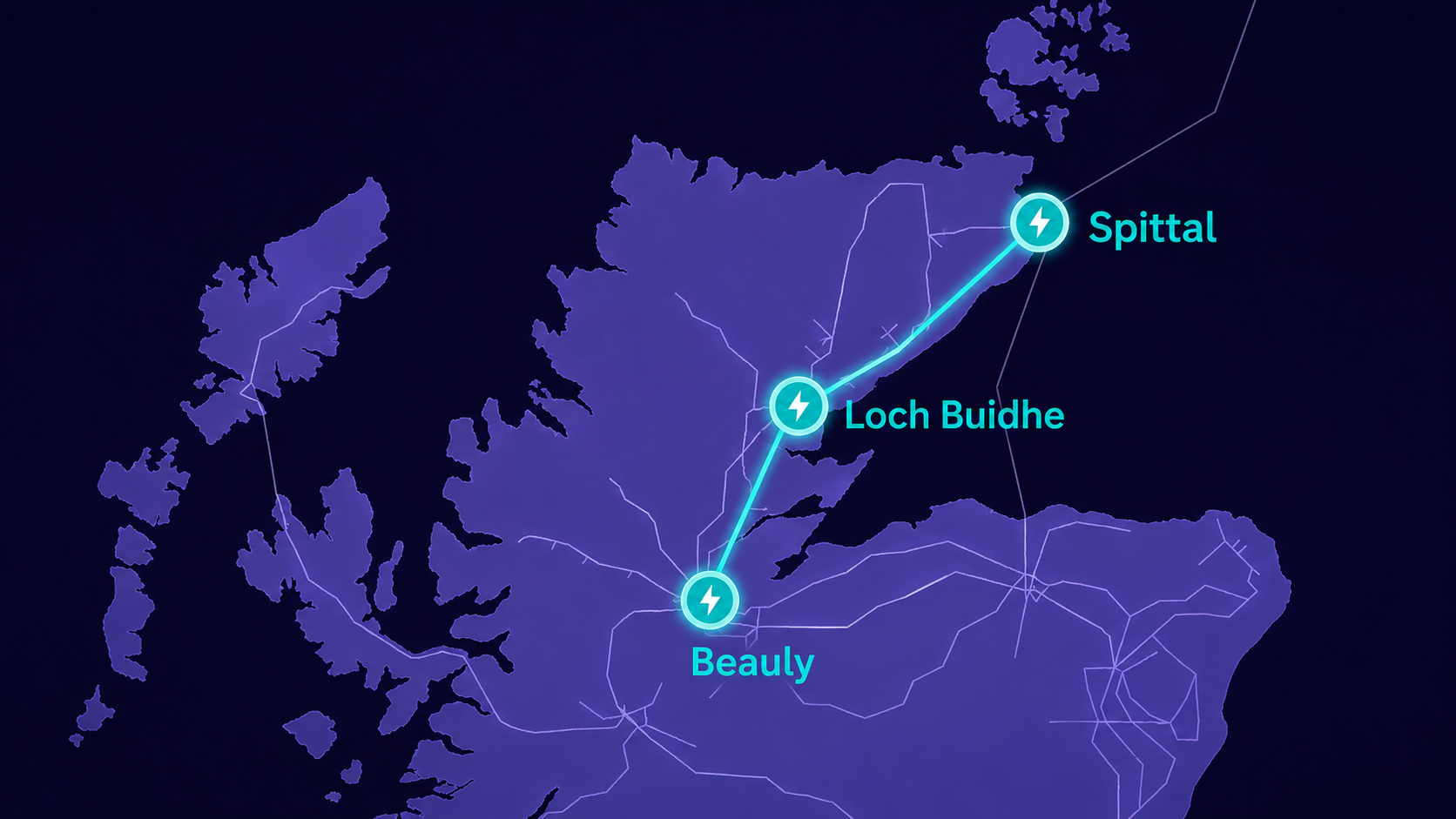
The proposal is the Spittal to Loch Buidhe to Beauly 400kV overhead line, promoted by SSEN Transmission as part of its wider Pathway to 2030 programme. It would run for about 173km between a proposed new substation at Banniskirk, in the Spittal area of Caithness, and Fanellan, near Beauly, with a connection through a proposed new substation at Carnaig, near Loch Buidhe. The application is before the Scottish Government’s Energy Consents Unit under reference ECU00006008 and is listed as an overhead power line project at consultation stage.
The line is not a small local upgrade. It would be a major steel lattice tower route across a long stretch of the north Highlands, with associated works including permanent diversion of existing overhead lines, temporary diversion works, access routes and ancillary development. The Energy Consents Unit description says the proposed development would include approximately 191km of new overhead line when diversion works are included.
The case for the line sits inside a much larger shift in Britain’s electricity system. The north of Scotland is producing increasing volumes of renewable power, while the grid that carries electricity south and across Britain was not designed for the scale of generation now being planned. SSEN Transmission has said the project forms part of its wider Pathway to 2030 programme, with investment of at least £22bn to March 2031, potentially rising to £31.7bn.
Historic Environment Scotland accepts that the line is a National Development under Scotland’s fourth National Planning Framework, which means the need for the project has already been established at national policy level. The dispute is over how that reinforcement is designed, where it passes, and what it does to communities, landscapes and historic places along the way.
The project’s public development has unfolded in stages.
The wider need arose from the Pathway to 2030 work published in 2022, which identified major transmission reinforcements needed to connect renewable generation and meet 2030 targets. SSEN says the Spittal to Loch Buidhe to Beauly project has been through a detailed development process since 2022.
The project was introduced to communities in February 2023, when SSEN consulted on route options of about 1km wide. That consultation closed on 14 April 2023, with more than 1,000 written responses received. A route selection phase followed in 2023, with reports on consultation and confirmation of which broad route options would be taken forward.
In March 2024, SSEN held further local engagement events, showing more refined routes. In May and June 2024, it carried out alignment consultation, including alternative alignments in some locations. By January 2025, SSEN had published a final Report on Consultation, following three rounds of overhead line route consultation and three rounds of consultation on potential substation locations. The company said this amounted to 37 in person events and one virtual event.
Ground investigation works began before final approval of the line itself. SSEN’s project material says ground investigation works for the northern section, from Spittal to Loch Buidhe, began in August 2024 and were expected to run through 2026. Ground investigation works for the southern section, from Loch Buidhe to Beauly, began in February 2025 and were also expected to continue through 2026. These works are not the same as full construction of the overhead line, but they are physical investigation works connected to the proposed route.
In August 2025, SSEN announced that it intended to submit its Section 37 consent application within two weeks. The company described that as a major milestone after what it called one of the biggest public consultation exercises the north of Scotland had seen.
The application was then submitted to the Scottish Government’s Energy Consents Unit. The ECU records the application as received on 14 August 2025. Highland Council published confirmation of the application on 24 October 2025 and said the case would be determined by the Energy Consents Unit, with the council acting as statutory consultee.
Who is objecting?
The most important heritage objection came from Historic Environment Scotland, the statutory body responsible for Scotland’s historic environment. On 7 October 2025, HES said the current proposal would have significant adverse impacts on the integrity of the setting of twenty eight scheduled monuments. HES also said the Environmental Impact Assessment Report did not provide sufficient evidence that the impacts on the historic environment had been fully taken into account in the design process, and therefore objected to the proposal in its current state.
The position has since shifted slightly. On 17 April 2026, HES updated its response, saying additional environmental information had helped clarify some impacts. It had withdrawn its objection to three of the twenty eight scheduled monuments and had been able to provide more detailed comments on seven. It also withdrew its objection relating to Fairburn Inventory Garden and Designed Landscape. That does not remove the wider concern. It means the dispute has narrowed, not disappeared.
There are also community and local objections. Kilmorack Community Council submitted a formal objection prepared by chartered planner Ian Kelly MRTPI, arguing that the cumulative effects of multiple renewable energy related proposals across Caithness, Sutherland and Ross shire were being considered through fragmented single project decision making rather than one coordinated forum.
Creich Community Council has also raised concerns, including criticism of the information available on the need for the line, its purpose and its relationship to existing power lines. Around Carbisdale, Samantha Kane, owner of Carbisdale Castle, has also been reported as opposing pylons near the property, arguing that they would harm the castle’s setting and future viability.
The risk to the twenty eight monuments is not necessarily that every site would be physically dug up or destroyed. Some risks are direct. Others are about setting, which is often harder for the public to picture but central to the meaning of many prehistoric sites.
SSEN’s cultural heritage chapter says its assessment identified 5,014 cultural heritage assets as part of the baseline, with 1,296 added to a gazetteer as assets potentially susceptible to direct or setting impacts. It identified 76 significant adverse effects to cultural heritage assets, including 32 direct physical impacts from construction groundworks and 44 effects from adverse changes to setting. The majority of significant effects were identified in Section A, which passes through an area of concentrated archaeological activity.
A chambered cairn, standing stone, broch or hillfort is not simply an object in a field. Its relationship with horizon, route, water, settlement, burial ground, skyline and neighbouring monuments can be part of why it matters. A pylon line may not touch the stones, yet still alter how the monument is experienced and understood.
The twenty eight scheduled monuments
The following list is a careful reconstruction from publicly available Historic Environment Scotland and SSEN Transmission material. Historic Environment Scotland’s public statement refers to twenty eight scheduled monuments affected by significant adverse setting impacts, but does not name all twenty eight in that statement. The names below are drawn from SSEN’s cultural heritage assessment and additional cultural heritage visualisation documents. Because HES has since withdrawn its objection in relation to three monuments after further information, the list should be read as the group of monuments originally identified through the public project material, not as a final determination of unresolved objection for every site.
1. Achkinloch, stone setting south west of Loch Stemster, SM420
This is a prehistoric stone setting near Loch Stemster. Stone settings are often important not only as individual monuments but as parts of wider ritual and funerary landscapes. HES asked for photomontages along the key south south east to north north west axis of the setting, in both directions, wide enough to include the stones and the proposed overhead line. That is telling. The risk here is not simply proximity, but interruption of the monument’s visual axis. Over the long term, the danger is that a site once read through open landscape becomes read through industrial infrastructure.
2. Buolacrabher, chambered cairn 1550m south of, SM445
This is a chambered cairn, part of the prehistoric burial and ritual landscape of Caithness. Chambered cairns matter because they are among the most visible remains of early farming communities and their treatment of the dead. The likely risk is setting change from towers and conductors in outward views. In the long term, the cairn’s relationship with neighbouring prehistoric sites and open ground could be weakened, even if the cairn itself is not physically touched. SSEN’s additional visualisation material records that HES sought a fuller view showing the pylons in the view from the cairn to the south.
3. Buolacrabher, chambered cairn 1350m south south west of, SM5224
This is another chambered cairn in the same broad archaeological landscape. Its importance lies partly in its relationship with other cairns, settlements and routeways. The danger is cumulative. One pylon may be survivable in visual terms; a long new transmission corridor can alter the whole character of a prehistoric landscape, making individual monuments appear isolated rather than connected. HES requested a photomontage looking from this cairn to the south and across SM445, which underlines the importance of intervisibility between monuments.
4. Cnoc na Maranaich, chambered cairn, burial cist and standing stone, SM443
This is a more complex prehistoric site, combining a chambered cairn, burial cist and standing stone. That combination suggests a long lived place of burial, memory and marking. Its importance is not merely architectural. It records repeated use of a place across time. The project risk is therefore especially sensitive: if pylons intrude into the sightlines around a cairn and standing stone complex, they may reduce the ability to understand why that place was chosen and how it related to the surrounding ground.
5. Loedebest, settlement, SM5152
Loedebest is a prehistoric settlement site. Settlement remains are essential because they reveal daily life rather than only burial or ceremonial activity. The risk is setting change, but also the broader cumulative impact of routing infrastructure through an area of concentrated archaeology. A settlement’s value comes from its relationship to land use, water, nearby cairns and other settlements. Long term industrialisation can flatten that context.
6. Loedebest, cairn 500m south south east of, SM5191
This cairn near Loedebest is part of a wider cluster. SSEN’s additional visualisation material includes it among sites for which further photomontage work was prepared. The risk is likely visual and cumulative. A cairn may be small in physical scale, but its placement in open landscape is often part of its cultural meaning.
7. Achorn Bridge, prehistoric and post medieval settlement 400m east north east of, SM512
This site is important because it contains evidence from more than one period. HES requested a photomontage showing pylons in the view looking north towards the Loedebest settlement sites, with a wide field of view to capture the full skyline. That means the issue is not merely the monument itself, but the visual relationship between settlement groups across the landscape. The long term risk is loss of legibility between related places.
8. Upper Borgue, broch, SM596
A broch is one of Scotland’s most distinctive Iron Age monument types: a substantial stone roundhouse, often associated with status, defence, settlement and control of land. Upper Borgue is therefore not just a ruin. It is part of the Iron Age story of Caithness and Sutherland. The project risk is likely the intrusion of new towers into views from and towards the broch. In the long term, this may weaken the sense of the broch as a commanding structure in its own landscape.
9. Upper Borgue, standing stone 410m south south east of, SM502
This standing stone near Upper Borgue is part of the prehistoric monument pattern around the broch landscape. Standing stones can be highly dependent on alignment, horizon and intervisibility. The risk is that an overhead line becomes a competing vertical presence, visually confusing a monument whose meaning may partly lie in its solitary placement.
10. Caen, long cairn and round cairn 470m and 490m west of, SM1770
Long cairns and round cairns are key elements of prehistoric burial and ritual landscapes. A long cairn is especially important because it often belongs to early monumental traditions. The risk is that pylons and wires intrude into views that connect these monuments to the Caen landscape. Long term, the danger is not immediate destruction but a permanent change in how the monuments are read.
11. Clach Mhic Mhios, standing stone, Glen Loth, SM1778
This standing stone in Glen Loth is a landmark monument. Its importance lies in its survival as a single upright prehistoric marker and in its relationship with glen, route and horizon. HES sought additional visualisation work for it. The risk is that a modern pylon line may compete with or dominate the stone’s vertical presence.
12. East Kinnauld, fort 100m north east of Eiden, SM1861
East Kinnauld is a fort, likely valued for its defended position and relationship to surrounding views. HES asked for 360 degree photomontages to show the impacts of proposed and existing pylons. That is a strong signal that the monument’s outward visibility is central to its significance. The risk is a change in the whole visual envelope of the fort, not one narrow view.
13. East Kinnauld School, broch north east of, SM1862
This broch is another Iron Age site whose meaning depends heavily on position. HES again asked for 360 degree photomontages to demonstrate impacts from the proposed pylons and existing pylons. The long term concern is cumulative modernisation of the broch’s landscape, making it harder to experience the site as part of an Iron Age pattern of settlement, control and visibility.
14. Balnacrae, chambered cairn 230m west south west of, SM2396
Balnacrae appears to be one of the most sensitive sites in the assessment. SSEN’s cultural heritage chapter says the proposed development would potentially result in a significant adverse impact on the integrity of the setting of this scheduled monument. HES asked for photomontages from near the cairn looking along its axis to see the pylons behind it, as well as views to the south. This is not a minor concern. It is a direct question about whether the project would compromise the monument’s setting in a way that affects its integrity.
15. Dun Mor, fort, SM4979
Dun Mor is a fort. HES criticised the existing photomontage for focusing on the nearest pylons rather than key views to the south and east, and requested full height photomontages showing pylons in those outward views. The risk is that the development could affect the fort’s strategic and landscape setting, particularly the views that help explain why the fort was built where it was.
16. Dun Garbhlaich, fort, Kilmorack, SM2422
Dun Garbhlaich is a fort in the Kilmorack area. HES asked for photomontages showing pylons in outward views from the monument and inward views from the lower terraces looking back towards it with pylons in the background. That means both how the fort looks out and how it is seen from below matter. Long term, the risk is erosion of the monument’s prominence within its landscape.
17. Balcraggie Lodge, settlement 700m north of, SM5230
This is a settlement monument. Its importance lies in evidence of past occupation and land use. The risk is likely setting change, especially if towers alter the open or rural character around the site. Over time, the monument may become harder to understand as part of an older working landscape. HES sought further material to demonstrate the impacts of pylons on either side of the gorge of Dunbeath Strath above the scheduled monument.
18. Cairn Liath, long cairn and round cairn, SM438
Cairn Liath combines long cairn and round cairn elements. It is part of the prehistoric funerary landscape and appears in SSEN’s further visualisation material. The risk is to the monument’s setting and potentially to the ability to understand its relationship with neighbouring cairns and routeways.
19. Loedebest, chambered cairn 400m west north west of, SM5163
This chambered cairn forms part of the Loedebest cluster. Its importance is increased by that grouping. The risk is cumulative landscape change. Even if one cairn is not directly affected, a line of towers through the wider setting can break the visible relationship between monuments.
20. Clais Cairn, chambered cairn 550m south west of, SM424
Clais Cairn is another chambered cairn within the prehistoric Caithness landscape. Chambered cairns often depend on the experience of approach, horizon and open land. The main risk is alteration of setting and the long term normalisation of major transmission infrastructure within a ceremonial landscape.
21. Cnoc Bad Asgaraidh, chambered cairn 570m east of Langwell, SM423
This cairn near Langwell is part of the eastern Sutherland prehistoric landscape. Its importance lies in burial, monumentality and its relationship with other remains. The risk is setting change, particularly if towers appear in significant views from the cairn or between it and other monuments.
22. Turnal Rock, hut circle complex 250m north west of Langwell Tulloch broch, SM13631
A hut circle complex records domestic settlement, often from later prehistoric periods. Its proximity to a broch landscape makes it particularly important because it can help explain settlement organisation around larger Iron Age structures. The risk is that a pylon corridor may reduce the coherence of the wider archaeological landscape, especially where domestic and defensive sites are read together.
23. Caen, long cairn 460m north north west of, SM1771
This long cairn near Caen is part of a group of cairns around Helmsdale. Its importance lies in early monumentality and burial practice. The risk is setting intrusion, particularly where the cairn’s relationship with other Caen monuments matters.
24. Caen, long cairn 530m north west of Helmsdale, SM432
Another long cairn in the Caen and Helmsdale landscape, this monument contributes to a concentration of prehistoric burial sites. The risk is not isolated. It is cumulative, because multiple cairns in the same area may all experience the same new industrial skyline.
25. Rinsary, homestead 500m west north west of Berriedale, SM3473
This homestead near Berriedale represents past settlement and land use. Homesteads are important because they show occupation at a smaller human scale than forts and brochs. The risk is a change in setting and the loss of rural context. If the line becomes visually dominant, the site may be understood less as part of an older settlement pattern and more as a remnant beside infrastructure.
26. Buolacrabher, settlement 1170m south of, SM6014
This settlement near the Buolacrabher cairns is important because it helps connect burial and domestic landscapes. If cairns show how communities commemorated the dead, settlements help show how they lived. The risk is that the line fragments the relationship between these elements, making the landscape’s archaeological pattern harder to read.
27. Caen, hut circles and souterrain, SM1841
Hut circles and souterrains are significant evidence of later prehistoric settlement and storage or refuge practices. A souterrain, as an underground structure, is particularly valuable for understanding domestic life, storage and social organisation. The risk may include setting change, but also concern over nearby groundworks, access tracks and construction disturbance if any works approach sensitive deposits. Long term, the issue is the preservation of both visible and buried archaeology.
28. Caen Burn West, 935m west north west of Caen, SM13647
Caen Burn West appears in the project’s cultural heritage visualisation list. Its importance lies in the wider Caen prehistoric landscape. The risk is once again cumulative: not one monument in isolation, but a chain of monuments whose shared setting could be altered by a major overhead line corridor.
Unresolved questions
The line is being advanced as part of Scotland’s clean energy future. That does not make the heritage concern trivial. It makes it sharper.
The north Highlands are being asked to host the infrastructure that will carry renewable electricity through Scotland and into the wider British grid. Some of that infrastructure may be necessary. But necessity is not the same as permission to treat the landscape as empty.
The documents show that this is not a case of one or two local objections raised late in the process. The developer’s own cultural heritage chapter identifies thousands of heritage assets in the study area, significant adverse effects, direct physical risks from groundworks, and setting effects across scheduled monuments. Historic Environment Scotland, having reviewed the material, objected because it did not consider the evidence sufficient to show that historic environment impacts had been fully taken into account.
The long term concern is whether net zero infrastructure will leave the Highlands with a better future or simply a more industrialised landscape carrying power elsewhere.
Sources
Historic Environment Scotland, Our response to the proposed Spittal to Loch Buidhe to Beauly 400kV overhead line. Published 7 October 2025 and updated 17 April 2026. Used for HES’s objection, the reference to twenty eight scheduled monuments, the National Development context, and the later withdrawal of objection for three monuments.
Scottish Government Energy Consents Unit, Application ECU00006008: Spittal to Loch Buidhe to Beauly 400 kV OHL Connection. Used for application status, project description, line length, applicant information, voltage and application received date.
Highland Council, Spittal to Beauly Overhead Electricity Line Application. Published 24 October 2025. Used for the council’s description of the application, route description and statutory consultation position.
SSEN Transmission, Spittal to Loch Buidhe to Beauly 400kV Connection project page. Used for project background, project documentation and ground investigation updates.
SSEN Transmission, Volume 2, Chapter 12: Cultural Heritage, Environmental Impact Assessment Report. Used for cultural heritage baseline figures, the 5,014 heritage assets, 1,296 gazetteer assets, 76 significant adverse effects, direct physical impacts, setting effects and the Section A concentration of archaeological effects.
SSEN Transmission, Additional Information, Volume 5, Appendix 12.8.1: Cultural Heritage Visualisations. Used for the reconstructed monument list and HES requests for additional photomontages and visualisations.
SSEN Transmission, Consent application announcement, August 2025. Used for the Pathway to 2030 context, investment figures and consent application timetable.