

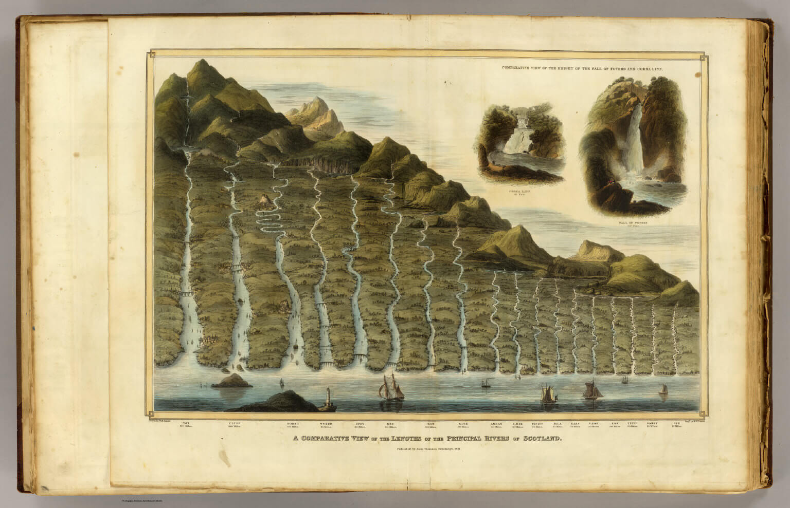
A comparative view of the lengths of the principal rivers of Scotland with a comparative view of the height of the falls of Foyers and Corba Linn.
Drawn by W.H. Lizars. Published by John Thomson of Edinburgh in 1831.
Introduction The rivers of Scotland weave through the landscape like threads of silver, each telling its own story of the land, culture, and history. On our website, we feature a detailed map titled “A Comparative View of the Lengths of the Principal Rivers of Scotland,” meticulously drawn by W.H. Lizars and published by John Thomson of Edinburgh in 1831. This invaluable cartographic piece not only outlines the lengths of Scotland’s major rivers but also offers a comparative view of the notable waterfalls such as the Falls of Foyers and Corra Linn.
Map Overview The map serves as a visual encyclopedia of Scotland’s hydrography, presenting the rivers not merely as physical features but as vital arteries that have supported both the natural and human landscapes for millennia. From the winding paths of the Tay, Scotland’s longest river, to the dramatic cascades of Corra Linn, the second highest waterfall in the UK, each element is captured with scientific accuracy and artistic finesse.
Exploration and Discussion Each river on the map tells a unique tale. For instance, the River Clyde, famous for its historical shipbuilding industry in Glasgow, contrasts with the more tranquil and picturesque settings along the River Spey, renowned for its world-class whisky distilleries. This map invites viewers to explore these stories, providing a basis for understanding the geographical diversity and cultural richness tied to Scotland’s waterways.
The comparison of the rivers’ lengths highlights not only their physical measurements but also their significance in agriculture, trade, and recreation. The inclusion of waterfall heights adds a dimension of natural beauty and power, illustrating Scotland’s dynamic landscapes formed by geological processes over the ages.
Educational and Historical Significance Originally published in the early 19th century, this map is more than just a geographical record; it is a snapshot of historical cartography, showcasing the skills and tools of the era. For educators, students, and enthusiasts of Scottish history, the map serves as a crucial resource in understanding how the natural environment has influenced social and economic developments.


