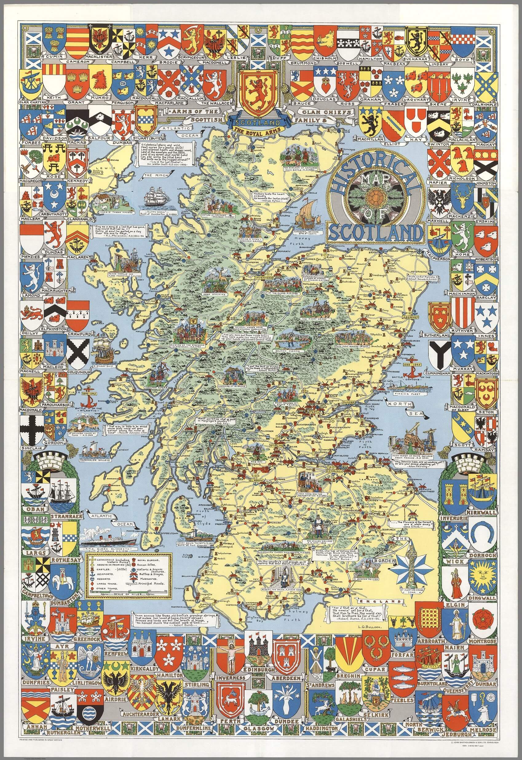
This historical map by L.G. Bullock, was printed and published by John Bartholomew & Son Ltd. in 1950. It is a richly detailed cartographic representation that serves both as a visual historical archive and a piece of art. This map is part of a tradition of decorative maps that blend geographical information with historical and cultural elements, making them both educational tools and collectible items.
Features of the Map:
- Coats of Arms: The inclusion of the coat of arms for main cities and towns adds a heraldic and genealogical dimension, highlighting the historical governance and the significant families associated with those regions.
- Clan Chiefs: By featuring the principal Scottish family and clan chiefs, the map provides insight into Scotland’s feudal and clan systems, which have played a crucial role in the country’s history. This aspect would be particularly valued by those interested in Scottish ancestry and the historical distribution of clans.
- Historical Sites: The map marks the sites of cathedrals, abbeys, castles, and battlefields. This feature makes it a valuable resource for historians and tourists alike, offering a snapshot of Scotland’s rich architectural heritage and tumultuous past.
- Artistic Illustrations: The detailed illustrations of places and events that have shaped Scotland’s history help contextualize the geographical information, providing a narrative element that enriches the viewer’s understanding of Scotland’s cultural and historical landscape.
Cultural and Educational Value: The map is likely to appeal to a wide range of enthusiasts including historians, educators, genealogists, and those with a general interest in Scottish culture. It serves as a bridge between Scotland’s past and present, illustrating how historical events and figures have shaped the modern landscape.
Publishing Background: John Bartholomew & Son Ltd., the publisher of this map, has a long history of cartographic excellence and innovation. Established in the 19th century in Edinburgh, Bartholomew was renowned for detailed and precise maps and atlases. Their work often included thematic and specialty maps, of which this historical map is a prime example.
Collection and Display: Maps such as this one are not only used for reference but are often collected and displayed due to their aesthetic value and historical significance. They can be framed and used as educational tools in classrooms, libraries, or personal studies.
Learn more about this map and get a free copy on the Internet Archive here: Scotland Map by L.G. Bullock