
Nine limestone boulders have been placed inside a protected harbour porpoise habitat to obstruct bottom trawling. The UK marine regulator has warned against further placements, while Scotland is consulting on fishing restrictions across 166 protected sites and areas.
Greenpeace is preparing to place another giant limestone boulder in the North Sea despite a warning of possible legal action from the UK marine regulator, escalating a dispute over industrial fishing inside waters officially designated to protect harbour porpoises.
On 10 November, the environmental organisation unveiled a boulder carved into the likeness of naturalist Sir David Attenborough aboard its ship Arctic Sunrise on the River Thames. Greenpeace intends to lower the sculpture onto the seabed to complete an underwater barrier designed to prevent fishing vessels from dragging heavy nets and equipment across a protected area off England’s east coast.
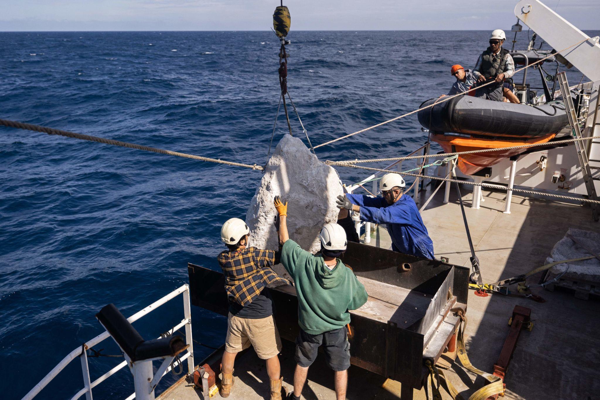
The announcement follows an operation on 31 October in which Greenpeace deployed nine limestone boulders, each weighing up to two tonnes, inside the Southern North Sea Marine Protected Area.
The group claims that the carefully positioned stones have made approximately 116 square kilometres, or 45 square miles, of seabed unsuitable for bottom trawling.
However, the Marine Management Organisation (MMO), which regulates fishing and marine activities in English offshore waters, has intervened.
According to Greenpeace, the regulator sent a letter on 5 November demanding that it stop placing boulders and warning of possible legal action.
The letter itself has not been independently examined for this article, and no court ruling establishing the legality of the operation has been identified.
The MMO has separately published the reported positions of the nine boulders to warn fishermen and other sea users about their presence.
The confrontation raises a wider question about the effectiveness of Britain’s marine conservation system: why does an area designated specifically to protect harbour porpoises continue to permit extensive bottom fishing, and who should decide which activities are compatible with its protection?
The issue has particular relevance to Scotland, where restrictions on fishing in offshore protected areas came into force in October 2025 and a further consultation covering 166 inshore sites and areas remains open until 18 January 2027.
Nine Boulders Placed on the Seabed
The original Greenpeace operation took place on Saturday 31 October.
Activists aboard the Arctic Sunrise lowered nine limestone boulders into the Southern North Sea Special Area of Conservation, a vast protected area extending along England’s eastern coast.
The boulders were positioned to interfere with the operation of bottom-towed fishing gear.
Bottom trawling involves dragging nets and associated equipment along or very close to the seabed to catch fish and shellfish.
Depending on the fishing method, the equipment may include heavy metal components, chains, doors or other devices that maintain the position of the gear as it moves across the seabed.
Greenpeace’s approach is intended to make selected areas too risky or impractical for this equipment to operate.
The organisation says its boulders have effectively excluded bottom trawling from an area of 116 square kilometres.
That figure requires qualification.
The nine stones do not physically cover 116 square kilometres. Rather, Greenpeace has placed them at selected locations to create obstacles which it believes fishing vessels will avoid.
The area affected therefore represents the campaign group’s assessment of the practical deterrent effect, not a newly established statutory fishing exclusion zone.
There is also no published independent assessment demonstrating that all bottom-trawling activity has ceased within the area claimed.
The boulders cannot prevent every fishing method, including some forms of fishing that do not involve dragging equipment across the seabed.
Greenpeace has called the area an Ocean Park, borrowing the idea of protected landscapes on land. The designation has no equivalent statutory status and does not create a legally enforceable marine reserve.
Authorities Issue Warning to Fishing Vessels
The Marine Management Organisation responded on 2 November by publishing the reported positions of all nine boulders.
The coordinates had been supplied by Greenpeace to HM Coastguard and subsequently shared with the regulator.
However, the MMO made an important qualification: it had not independently verified every position.
The agency advised mariners to take account of the reported locations when planning and conducting their activities.
Ireland’s Sea-Fisheries Protection Authority issued a separate notice on 4 November, confirming that nine limestone boulders had been deployed and reproducing the locations for the benefit of the fishing industry.
The notices illustrate the immediate safety implications of deliberately placing large obstacles in areas used by commercial fishing vessels.
A bottom-towed net or other heavy fishing equipment that encounters an unexpected obstruction can become damaged or snagged. Depending on the circumstances, that can also create risks for the vessel and crew.
Greenpeace argues that providing the coordinates makes the operation safe and allows fishing vessels to avoid the affected areas.
But publishing positions does not independently establish that every vessel has received the information or that all the relevant hazards have been eliminated.
The regulatory question is separate from whether the protest supports a legitimate environmental objective.
Marine conservation policy must also account for navigation safety, existing fishing rights and the consequences for vessels operating in the area.
Greenpeace maintains that its actions constitute peaceful environmental protest and says it intends to complete the barrier despite the regulator’s warning.
Its latest announcement does not confirm that the additional Attenborough-shaped boulder has already been deployed.
Why the Southern North Sea Is Protected
The Southern North Sea Special Area of Conservation was formally designated in February 2019 to protect harbour porpoises.
The site covers approximately 36,951 square kilometres, stretching from waters north of Dogger Bank towards the Strait of Dover.
It includes important summer and winter habitats for the species.
The Joint Nature Conservation Committee (JNCC), the government’s statutory adviser on nature conservation in offshore waters, estimates that the site supports approximately 17.5% of the UK North Sea harbour porpoise population.
That is a substantial proportion of the population using British North Sea waters.
Harbour porpoises are among the smallest cetaceans found around Britain.
They rely on echolocation to navigate, locate prey and interpret their underwater environment.
Their diet includes small fish and other marine organisms, making the availability of suitable prey an important factor in their survival.
The conservation objectives established for the Southern North Sea site include maintaining viable porpoise populations, preventing significant disturbance and protecting the habitats and ecological processes needed to maintain food supplies.
However, designation as a Special Area of Conservation does not automatically prohibit every activity that might affect wildlife.
Fishing restrictions must be introduced through the applicable management and regulatory processes.
This distinction lies at the centre of the current dispute.
The site is legally designated for conservation, but much of it remains accessible to commercial fishing vessels.
The JNCC’s published assessment records the site’s designated harbour porpoise feature as being in favourable condition. That classification should not be overlooked: the designation and the existence of pressures do not establish that the local population is currently collapsing.
The central concern is whether existing management measures are sufficient to maintain favourable conditions over the long term.
More Than 30,000 Hours of Apparent Bottom Fishing
The scale of fishing activity inside the protected area is substantial.
Research published by marine conservation organisation Oceana UK earlier this year identified 30,936 hours of apparent bottom-towed fishing activity within the Southern North Sea site during 2025.
Greenpeace subsequently published its own analysis, estimating at least 37,200 hours during the same year.
These are different figures derived from analyses of vessel-tracking data.
Both organisations used information associated with Global Fishing Watch, which estimates fishing activity from vessel movements recorded through Automatic Identification System signals and computer models.
The numbers are therefore estimates of apparent fishing activity rather than a complete record of catches or independently observed hours of trawling.
The two organisations’ publicly available findings do not provide enough directly comparable detail to establish the precise reason for the difference.
Differences in the vessels included, fishing gear classifications, processing methods and data versions can affect such estimates.
The figures should not be combined or presented as independently verified measurements of exactly the same activity.
However, both analyses identify intensive bottom-towed fishing inside a site designated to safeguard harbour porpoises.
Greenpeace’s wider analysis estimates that trawlers and dredgers operated for at least 115,000 hours inside UK offshore Marine Protected Areas during 2025.
It also estimates that bottom-towed gear disturbed a cumulative 55,600 square kilometres of seabed within those areas.
That cumulative area should not be confused with the total unique area of seabed affected. The same location may be crossed repeatedly, and repeated fishing tracks can contribute more than once to cumulative disturbance.
The estimates nevertheless indicate the scale of industrial activity taking place within waters that carry marine conservation designations.
How Bottom Trawling Affects Harbour Porpoises
The environmental case for restricting bottom trawling involves more than the immediate disturbance of the seabed.
Heavy fishing equipment can damage or remove organisms living on and within seabed habitats.
Repeated disturbance can alter the physical structure of those habitats, affect the animals they support and change the availability of food for other marine species.
Marine ecologists also identify underwater noise and the disturbance of sediment as potential pressures on animals that rely on sound or visibility when feeding.
For harbour porpoises, maintaining the availability of suitable prey is particularly important.
Research compiled by Oceana UK identifies possible effects from prey depletion, habitat disturbance and fishing noise.
Professor Emma Sheehan, a marine ecologist at the University of Plymouth, has highlighted the importance of wider ecosystem conditions for seabirds and cetaceans, rather than concentrating solely on the animals living directly on the seabed.
However, the threats to porpoises must be distinguished carefully.
One of the most serious direct causes of harbour porpoise mortality associated with fishing is accidental entanglement in nets, particularly certain types of static net.
A measure designed to obstruct bottom trawling will not necessarily prevent that form of bycatch.
Nor would the placement of nine boulders resolve all the pressures affecting the species.
An effective conservation strategy may require different measures addressing seabed disturbance, availability of prey, fishing-related mortality and other sources of underwater disturbance.
The Greenpeace operation is therefore best understood as an attempt to restrict a particular fishing practice within part of the protected area, rather than a comprehensive solution for harbour porpoise conservation.
Its actual ecological benefits have not yet been independently demonstrated.
A Separate Regulatory Process Covers Harbour Porpoises
The underlying regulatory position is more complicated than the simple claim that ministers have failed to ban trawling.
The Marine Management Organisation is undertaking a phased programme to assess the effects of fishing activities on English Marine Protected Areas.
Earlier stages introduced restrictions on bottom-towed fishing gear in designated areas.
The Dogger Bank Special Area of Conservation, for example, became subject to a bottom-towed fishing gear byelaw in 2022.
A later programme considered additional protected areas containing seabed habitats.
In 2025, the MMO consulted on restrictions covering approximately 30,000 square kilometres within more than 40 protected areas in English waters.
The consultation closed in September 2025, with the regulator subsequently examining the large number of submissions received.
However, the Southern North Sea harbour porpoise site falls within a different part of the programme.
The MMO identifies it as a Stage 4 site, covering protected areas designated for highly mobile species.
That stage also includes the Bristol Channel Approaches harbour porpoise site and three protected areas designated for seabirds.
The regulator says its work includes engagement with the fishing industry, environmental organisations and other stakeholders to reduce accidental capture of harbour porpoises.
The distinction matters because introducing restrictions to protect seabed habitats is not necessarily the same regulatory exercise as determining the measures needed to conserve a mobile marine mammal.
In July, the UK Government was asked in Parliament to assess the environmental implications of more than 30,000 hours of apparent bottom trawling in the Southern North Sea protected area.
The response referred to the separate consultation covering further seabed protected areas and said decisions would be made after submissions had been considered.
It did not provide a specific assessment of the environmental consequences of the recorded activity within the harbour porpoise site.
That gap helps explain why campaigners continue to question whether official designation is delivering the protections intended.
Why Greenpeace Has Escalated Its Campaign
The organisation’s latest operation follows earlier campaigns in British waters.
Greenpeace deployed boulders on the Dogger Bank in 2020, seeking to deter bottom trawling before stronger restrictions were introduced.
In 2022, its vessel Arctic Sunrise carried out a similar operation in the South West Deeps Marine Conservation Zone, off south-west England.
The tactic has become a distinctive element of the organisation’s campaign against bottom-towed fishing in protected areas.
It is also controversial because it involves campaigners physically altering fishing conditions without having the statutory powers normally used to establish marine restrictions.
The current campaign began before the latest boulders were deployed.
Greenpeace says it warned the UK Government in June that it would consider direct action unless further progress was made towards protecting offshore marine areas.
It began the Southern North Sea operation at the end of October.
The 10 November unveiling of the Attenborough-shaped boulder was intended to draw further attention to the issue.
The sculpture has been named Attenboulder, and Greenpeace says it will complete the barrier already established.
The organisation also reported that its vessel had approached seven industrial fishing boats longer than 33 metres during the preceding weekend to request that they stop fishing inside the protected area.
Such requests do not themselves have the force of law.
Greenpeace has support from several parliamentarians and public figures, including MPs who signed some of the original boulders.
But the participation of elected representatives does not substitute for the statutory process required to create fishing restrictions.
The disagreement is ultimately about both conservation outcomes and the authority to decide how British waters should be managed.
Scotland Has Introduced Its Own Offshore Restrictions
Although the Greenpeace operation took place in English offshore waters, it raises questions that are directly relevant to Scotland.
Management of fisheries and marine conservation is divided between different administrations and regulatory systems.
The Scottish Government has responsibility for fisheries management measures in Scottish waters, subject to the applicable legal framework.
On 16 October 2025, new restrictions came into force within Scotland’s offshore Marine Protected Areas.
The measures cover waters between 12 and 200 nautical miles from the coast and impose site-specific restrictions on fishing methods considered capable of damaging protected habitats and species.
Some areas prohibit particular forms of bottom-towed fishing gear. Others impose restrictions within specified zones rather than across an entire protected site.
For example, the Central Fladen Marine Protected Area, east of Scotland, has restrictions on demersal mobile fishing gear within two designated zones.
The restrictions include specified trawls, dredges and other bottom-contacting fishing methods.
The Scottish approach differs from a universal ban on trawling throughout every protected area.
The measures are tailored to the environmental features being protected and the assessed impacts of fishing activities.
The Government says the restrictions were developed through engagement with scientists, fishing organisations, environmental groups and coastal communities.
They are also subject to monitoring and evaluation.
This means that parts of Scotland’s offshore conservation network have moved beyond consultation into legally enforceable management measures, although the restrictions differ considerably between sites.
Another 166 Scottish Sites and Areas Are Under Review
The next stage of Scotland’s marine conservation programme concerns inshore waters.
On 14 September, the Scottish Government opened a consultation on proposed fisheries management measures covering 166 protected sites and proposed Priority Marine Feature management areas.
The proposals include 76 Marine Protected Areas and 90 proposed Priority Marine Feature management areas.
These areas are important because they contain habitats and species that may be particularly vulnerable to fishing gear operating on or near the seabed.
The consultation considers restrictions intended to protect sensitive habitats and species while accounting for the social and economic importance of commercial fishing.
The Government has identified 11 Priority Marine Features particularly sensitive to bottom-contacting mobile gear.
These include fragile seabed habitats and species whose conservation depends on reducing damaging physical disturbance.
The consultation runs until 18 January 2027.
The Scottish Government has also scheduled public engagement events to help coastal communities, fishing businesses and conservation organisations examine the proposals.
The economic consequences could be significant for vessels that depend on traditional fishing grounds.
Restrictions on where and how fishing can take place may alter operating costs, travel distances and access to particular catches.
They may also provide longer-term environmental benefits where reduced disturbance allows habitats and commercially valuable fish populations to recover.
The balance will depend on the specific areas affected, the fishing methods involved and the quality of the scientific and economic assessments.
The current Scottish consultation is therefore an important parallel to the dispute in English waters.
It concerns the same underlying question: how to translate marine conservation designations into measures that protect habitats and species while providing workable rules for fishing communities.
Harbour Porpoises Are Also Protected in Scottish Waters
Scotland has its own protected areas designated specifically for harbour porpoises.
Among them is the Inner Hebrides and the Minches Special Area of Conservation, which extends through waters along the western Scottish coast.
The area is recognised as important year-round habitat for harbour porpoises.
The species is widespread around Scotland, including the North Sea, waters around the west coast and areas extending towards Orkney and Shetland.
These animals do not observe national administrative boundaries.
Their conservation depends on conditions across extensive marine areas, including food availability, underwater disturbance and the risks associated with fishing equipment.
However, the existence of a Scottish harbour porpoise protected area does not mean that the same fishing activities, environmental pressures or regulatory measures apply there as in the Southern North Sea.
Each site has its own conservation objectives, ecological characteristics and management requirements.
That distinction is particularly important when comparing the Greenpeace protest with decisions being made by the Scottish Government.
The presence of harmful activities in one protected area does not establish that identical conditions exist in another.
Effective scrutiny requires evidence of the actual pressures affecting each site and whether the measures introduced are sufficient to address them.
Conservation and the Future of Fishing
The Greenpeace action has exposed a longstanding tension within marine management.
Protected areas are intended to safeguard important wildlife and habitats, but designation alone does not necessarily prohibit industrial activity.
Restrictions require scientific assessment, legal decisions and practical arrangements for enforcement.
Conservation organisations argue that these processes have moved too slowly and that continued bottom trawling undermines the credibility of marine protection.
Fishing businesses, meanwhile, depend on access to productive grounds and require clear, predictable rules when decisions affect their operations.
The environmental consequences of fishing methods are not uniform.
Different gear types affect seabed habitats and marine animals in different ways, and management measures need to reflect those distinctions.
Similarly, not every fishing vessel operating in a Marine Protected Area is automatically acting unlawfully.
The relevant question is whether the activity is permitted under the rules currently in force and compatible with the site’s conservation objectives.
Greenpeace has chosen to intervene physically rather than wait for further restrictions.
The MMO’s reported legal warning demonstrates that the method is contested, even as the underlying environmental concerns receive support from marine conservation research.
The precise legal outcome remains unresolved.
What Happens Next
The immediate question is whether Greenpeace will proceed with placing its additional carved boulder in the Southern North Sea.
Its 10 November announcement sets out that intention but does not establish that the placement has taken place.
The Marine Management Organisation has published navigation information for the original nine boulders, and Greenpeace says it has been warned against placing any more.
Any further action could therefore bring the dispute into a more formal legal setting.
Beyond the confrontation, the important test will be whether the existing barrier actually reduces bottom-trawling activity in the area.
That would require monitoring of fishing vessel movements over time, together with evidence capable of distinguishing activity displaced to other grounds from a genuine reduction in pressure on the marine environment.
Determining whether the intervention improves conditions for harbour porpoises would require a broader ecological assessment.
A reduction in trawling does not automatically establish improved prey availability or increased porpoise survival, particularly where other threats remain.
For Scotland, the issue is less about whether campaigners should place boulders in the sea than whether the existing system of marine protection produces measurable results.
Scotland has already introduced offshore fishing restrictions and is considering further measures across its inshore waters.
The decisions made following the consultation closing in January will help determine how much of Scotland’s protected marine environment is subject to effective restrictions, where commercial fishing can continue and what evidence will be used to judge success.
The North Sea protest demonstrates the consequences of a widening gap between the public expectation of protection and the activities that remain legally permitted.
Resolving that gap will require not only conservation designations, but clear rules, effective enforcement, consideration of fishing livelihoods and evidence that marine wildlife and habitats are actually benefiting.
Sources
Greenpeace Unveils Attenborough-Shaped Boulder to Deter Destructive Fishing. Greenpeace UK. 10 November 2026.
https://www.greenpeace.org.uk/news/greenpeace-unveils-attenborough-shaped-boulder-to-deter-destructive-fishing/
Greenpeace Activists Deploy Underwater Boulder Barrier to Protect Porpoises in UK’s Most Bottom-Trawled Nature Site. Greenpeace UK. 2 November 2026.
https://www.greenpeace.org.uk/news/greenpeace-activists-deploy-underwater-boulder-barrier-to-protect-porpoises-in-uks-most-bottom-trawled-nature-site/
MMO Statement: Boulder Positions in the Southern North Sea. Marine Management Organisation. 2 November 2026.
https://www.gov.uk/government/news/mmo-statement-boulder-positions-in-the-southern-north-sea
Boulder Barrier Created by Greenpeace in Southern North Sea Area. Sea-Fisheries Protection Authority, Ireland. 4 November 2026.
https://www.sfpa.ie/Who-We-Are/News/Details/boulder-barrier-created-by-greenpeace-in-southern-north-sea-area
Southern North Sea Marine Protected Area. Joint Nature Conservation Committee. Site information updated March 2023.
https://www.jncc.gov.uk/our-work/southern-north-sea-mpa/
Managing Fishing in Marine Protected Areas. Marine Management Organisation.
https://www.gov.uk/government/collections/managing-fisheries-in-marine-protected-areas
Bottom Trawling Bans Needed to Protect Porpoises and Puffins as Well as Seabed: New Report. Oceana UK. 2026.
https://uk.oceana.org/press-releases/bottom-trawling-bans-needed-to-protect-porpoises-puffins-as-well-as-seabed-new-report/
Marine Protected Areas Stage 3 Consultation. Marine Management Organisation. Consultation closed 29 September 2025.
https://www.gov.uk/government/collections/marine-protected-areas-stage-3-consultation
Bottom Trawling Activity in Harbour Porpoise Marine Protected Area: Written Parliamentary Question 18876. UK Parliament / Department for Environment, Food and Rural Affairs. Answered 17 July 2026.
https://questions-statements.parliament.uk/written-questions/detail/2026-07-14/18876/
Offshore Marine Protected Areas. Scottish Government. 1 September 2025.
https://www.gov.scot/news/offshore-marine-protected-areas/
Offshore Marine Protected Areas: Fisheries Management Measures — Supporting Guidance. Scottish Government. 1 September 2025.
https://www.gov.scot/publications/supporting-guidance-fisheries-management-measures-offshore-marine-protected-areas-coordinates-restrictions/pages/1/
Marine Protected Areas Consultation Launched. Scottish Government. 14 September 2026.
https://www.gov.scot/news/marine-protected-areas-consultation-launched/
Proposed Fisheries Management Measures for Inshore Marine Protected Areas and Priority Marine Feature Management Areas. Scottish Government. September 2026.
https://www.gov.scot/publications/proposed-fisheries-management-measures-inshore-marine-protected-areas-mpas-proposed-priority-marine-feature-pmf-management-areas-consultation-paper/pages/6/
Scottish Inshore Fisheries Consultation. Scottish Government. Closes 18 January 2027.
https://consult.gov.scot/marine-scotland/fisheries-management-measures-for-inshore-mpas/
Scottish Parliament Research Briefing: Marine Protected Areas and Fisheries Management. Scottish Parliament Information Centre. 28 September 2026.
https://www.parliament.scot/chamber-and-committees/research-prepared-for-parliament/research-briefings/2026/9/28/sb-2663
Inner Hebrides and the Minches Special Area of Conservation. Joint Nature Conservation Committee.
https://sac.jncc.gov.uk/site/UK0030393
Harbour Porpoise: Species and Conservation Information. Joint Nature Conservation Committee.
https://sac.jncc.gov.uk/species/S1351/